Arequipa to Chivay (Saturday 8 October)

I’ve signed onto a 2-day excursion to visit the Canon del Colca. The Colca canyon is set amongst high volcanoes and is considered the second deepest canyon in the world. It ranks slightly less than the Canon del Citahuasi, also in Peru, and both are more than twice the depth of the Grand Canyon. The township of Chivay is at the head of the Canon del Colca and that is where we camp for the night.

The bus picks me up at 7.30 and onto a climbing road to a pass in the Andes that reaches nearly 5000 meters. The landscape is like desert and the guide explains that the climate is getting drier each year. It wasn’t always this dry and they seem to blame the mining that is going on in the region. Copper is the main commodity mined. Agriculture is also big and in places water comes out of the ground. Snow melt is another source of water. There are alpaca and llama farms on the way. It’s very cold and the air is thin. Life in the winter time must be tough on the farms and in the villages. Traditional dress is common amongst the people and differs according to there cultural background. Before the Incas and the Spanish there used to be two main conflicting cultural groups in this region and the used to try and distinguish themselves in a very bizarre way. They would physical shape the heads of babies so they would grow up with cranial differences. One group would deform the heads into a cone shape while the other, flat top heads. Not surprisingly mortality was high. Too many babies were dying from the process so they stopped! Now the use distinctively shaped hats and embroidered traditional clothing to denote the ancestry.

Then the Incas came, then the Spanish, but still the two groups maintain their separate identities. And they seem to quietly occupy different parts of the Colca Valley. Today they live together in Chivay and you can tell the difference in the ladies hats. The Collagua ladies wear white hats while the Cabanas ladies were beautifully embroidered hats.

We climb over the highest pass to take us into the catchment area for the Amazon River and down into Chivay. Chivay was a quiet little agricultural village until tourists discovered the Canon del Colca. Now Chivay supports many hostels and restaurants and is busy with bus loads of travelers.

Every town in Peru it seems has it’s town square or Plaza de Armas and La Catedral, which is the Catholic church. Chivay is no different and it is alive with locals and tourists, and dogs and llamas.

20111009-161007.jpg
Traditional dancing in Chivay

Lima to Arequipa (Friday)

My flight to Arequipa us painfully early, 6am! It’s the cheapest time to fly and I am flying again with Peruvian Airways. It’s an hour flight over an interesting rugged mountainous landscape that appears entirely treeless and desolate but obvious trails everywhere suggests life down there somewhere. If my plane decides to stop flying there isn’t anywhere at all to gracefully land. Fortunately it is happy to fly and I get to Arequipa at 7am.

Arequipa is obviously a Spanish town with grand Spanish architecture everywhere. Even the people are more Spanish than many other places and I am told there are animosities between here and the more Inca-Spanish regions. The people are different here but I doubt I will appreciate that in the short time I am here. Like other cuties, the Plaza de Armas is the cultural, spiritual, social and administrative heart of the city. And again it is a square surrounded by majestic Spanish architecture. There is a difference though. The local materials sourced for construction are a very light colored rock so the grand structures are nearly white. It is very distinctive.

20111007-214051.jpg
The beautiful Plaza de Armas in Arequipa

It’s night now and at my restaurant I am surrounded by boisterous noise as people on both sides are cheering at television monitors. I have no idea of what it is about but I doubt it is the Rugby Worldcup…unfortunately!

Lima (Thursday)

Back to Lima. Today is an easy day to recover from my busy tour to Matchupicchu.

Time to sample some more local food and to organise where to visit next in Peru. There are if course many choices for places to go and with my friend Micht’s help and tourism knowledge I decide to visit the mountain city of Arequipa and to tour the Canon del Colca. The highlight of this tour is to see the magnificent condors.

I’m staying in a real working-class part of Lima but because it is close to the airport there are some fine restaurants around. Today we try a seafood restaurant and I order some local fish (can’t remember the name) and shrimps. The shrimps are a bit unusual and different to anything I have seen before. Very nice.

20111007-214016.jpg

Cuzco (Wednesday)

20111007-094949.jpg
Peruvians like to sculpture signs and messages into the mountain sides.

Cuzco us an Inca city and the evidence of this is in the buildings. Many of the buildings have the classic Inca-styled stonework base supporting Spanish architecture on top. It is a city of significance to the Incas, featuring in Inca legend and it us thought to be a mystical place with energy lines and cosmic connections. I didn’t sense any if that but it is an interesting city and does have a vibrant feel to it. There are constantly people everywhere.

After the Spanish came through they destroyed the Inca city and rebuilt it there way. Cuzco became just an ordinary regional town until Matchupicchu was discovered in 1911. Life changed as tourists started coming into. Today it is very much a tourist city but still retains heaps of character.

Today I return to Lima via Peruvian Airways and arrive around 2.30pm.

20111007-094847.jpg

Machupicchu (Tuesday)

‘To think that a civilization with the mind, desire and ability to create something of this magnitude could be completely destroyed by a civilization with purely materialistic ambitions is just wrong. Humanity took a giant step backwards that day.’
Angus McColl

Matchupicchu means ‘big mountain’ and is a modern name given to the famous Inca city because nobody knows what name the Incas gave the place. Another point of interest before I start describing my day – the word ‘Inca’ is not the name of a people’s but I title. Incas were king-like leaders.

20111005-115045.jpg

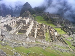
Apart from it’s impossible location and amazing architecture, Matchupicchu was an extraordinary place for other reasons. It was home to an elite group of people’s, chosen to be there by the Inca. They were at the clever end of the social scale – teachers, doctors, agriculturalists, artists and more. And of course architects and builders. Everything about the story of this place is conjecture and the Peruvians admit that. The guides are careful to add ‘It is our opinion that…’ to everything they tell us. Apparently this amazing city was only home to about 500 people!

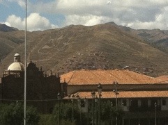
There had to be laborers and they came from outside. Instead of paying money for taxes, the people from the region were required to provide one months labour each year to the city of Matchupitchu. For a month each year they would come into the city and work. And work they did! The Inca Trail, now popular with tourists, was the main access to Cuzco and supplies. At that time Cuzco was a large Inca city. The trail today is only half the distance of the original path.

The city is built atop of a mountain. If you were to think of the most unlikely place to build a city, this would be it. Experts think the Incas built here to protect its precious population from enemies. It is also thought they wanted to be as close to their Gods as possible. And access to the right building materials was important too. They used the local granite.

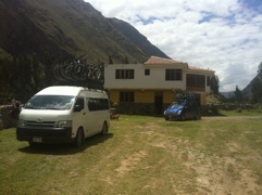
We start the day at 5 am. You can either choose to walk up the steps to the entrance of Matchupicchu or take a bus. The walk is tough and takes an hour and a half. To preserve energy for plenty of walking around the city I decide to bus up and do the steps down. It’s raining this morning so bussing it was a good choice. We get up the amazing looping road around 6.30pm. We start our visit to the city with a 2-hour guided tour and that is where I have got the information from for this blog.

That famous rock wall construction that is unique to Incan architecture is perfection. The whole city isn’t built of it though, only special parts including the Inca’s residence (of course) and places of worship. The rest was built of a simpler style of construction where a mortice was used to hold together not so perfectly fitting rocks. The morticed used has withstood 500 years of weathering. Nobody knows how they made this mortice. An attempt was made to duplicate it that only lasted two years. The classic Inca construction didn’t require mortice of any kind. The rocks were shaped to fit perfectly against each other. To do this they broke chunks of rock from granite boulders, then shaped and smoothed them with other harder rock into perfectly fitting blocks. The attention to detail for such a scale of construction must be unparalleled surely. To see this place was one of those ‘tears to the eyes’ moments for me, my second for the trip after the giant sequoias.

But there is much more to this amazing place. To be self-sustaining they needed to be able to crop. How do you do that on a mountain top? Terracing is how you do it. They built rock-wall terraces down the mountain side in places that simply look impossible. A pity the poor buggers that were sent to some of the crazy locations with instructions to build a rock wall. I would have taken a sickie that day! These terraces are all over and cover so much of the elevation of the city that the climate for cultivation varied from top to bottom. So crops were especially chosen for certain locations on the mountain edge. The soil was imported from the Cuzco region. Can you imagine that? The local soil wasn’t suitable so fertile soils were carried in over the Inca Trail.

Experts think there is much more of Matchupicchu yet to be revealed, hidden beneath dense rainforest. The magnitude of this place is enormous and takes more than a day to fully comprehend. Even the trail has some very sophisticated structures to make it possible. There is a bridge not far from the city that literally hangs off the side of a sheer cliff and this precarious structure, like the terracing, is intact all this time later.

Of course the development of Matchupicchu stopped with the arrival of the Spanish in 1521 (I think). The Spanish never found this place. They suspected it existed but failed to find it. Apparently a couple of German adventurers came across it in the 1850s and looted the site with the Peruvian governments permission. But it wasn’t until it was discovered by an American historian, Hiram Bingham, in 1911 was it revealed to the rest of the world. Lack of Government interest and protection at that time allowed Bingham to take many precious artifacts back to America.

Then there is Waynapicchu. It is a small steep peak at the back of Matchupicchu where there are more Inca ruins atop. Climbing Waynapicchu can be part of your visit to Matchupicchu and although a bit of an effort, is worth it. The Temple of the Moon lives here and you have to wonder, like the rest of the place, how they built this here. The views all around are insanely stunning, particularly the complete views of the city below.

The day ends with a train and bus ride back to Cuzco.

Cuzco to Santa Teresa (Sunday 2 October)

Today is the start of a 3-day bike/hike to Matchupicchu and back. It starts with a bike laden bus ride to a place called Abraham Malaga. The bus is a van and there are 13 of us with all our luggage packed in. I’m easily the oldest in the group by at least 20 years and clearly the only mono linguist amongst us. Even the American girl can speak Spanish. The chat is of the big night they have had and it’s not long before the whole bus is asleep, except for the driver, guides and me. Streaming past the windows is extraordinary scenery, clearly wasted on the most of us. Just over there are ice-covered mountains and way down in the deep valleys is the Rio Urubamba river and the city of Urubamba. It is a spectacular site because included in the picture is the road zig-zagging it’s way down from atop of the ridge we are on into the city.

We continue on to climb again on other snaking roads before we finally get to the top of a huge pass. It’s raining now and as we start our descent I swear I see out of the corner of my eye one of the guides crossing himself. You know, that thing Catholics do when they prey. Hmmm… Anyway he’s preys were either answered or were un-necessay because we arrive at the bike stage without problems.

It’s still raining so the riding on muddy roads is messy. This section is all downhill and the results are quite comical on some of the riders as they’re covered in completely in mud. We get to a village and we can decide to continue riding to Santa Maria or just get back into the bus. Most of the ‘kids’ take the easy option and it is just me and the American girl continuing the ride. The rain has stopped and the mud has dried so it’s easy to do the road now at speed. It’s fun. There is some up hill. The American girl’s bike breaks down so it is just me now. Somehow I seem to get lost. The road becomes a track and forks appear with signs that don’t make sense to me. I have to ask villagers for directions with my limited Spanish. I eventually get to Santa Maria behind the bus but I don’t recall it ever passing me! We obviously went different ways. The ride was great, passing through village life and running creeks.

Apart from the American, there is another Australian from Melbourne and the rest are from Israel. Israelies love to travel South America because it is cheap. They tend to do their compulsory time with the military then work for a year before traveling.

From Santa Maria it is a slow bus ride to the village of Santa Teresa where we stay the night in a hostel. The road is rough and is carved out of a steep ridge. Fortunately it is dark so the sheer drop at the edge of the narrow bumpy road is only briefly visible when exposed by the headlights. I’m glad we did that in the dark!

20111004-093829.jpg

We arrive into Santa Teresa about 7.30. Already it appeals to me. There is live music coming from a place just down from our hostel. There is plenty of life here, even in a Sunday night. I could spend months in Peru alone. It appeals greatly to all my senses.

Cuzco (Saturday 1 October)

Today is spent organising a tour to Matchu Pitchu. The Inca Trail is not available because I couldn’t get organised enough to pre-book so I’ve decided to do a 2-night, 3-day bike/hike tour that will give me a whole day at Matchu Pitchu. I arrive back in Cuzco late Wednesday night and fly out for Lima mid-day Wednesday.

The rest of the day is given to wandering the streets if Cuzco. There is plenty of activity on this Saturday with markets, parades and people everywhere going about their business.

The air here is thin and I’m suffering slightly with forced breathing and slight headaches. They recommend you drink a tea made out of cocoa leaves and it is readily available so I do that when I can.

20111002-101152.jpg
Inca statue in the main square, Plaza de Armas.

Lima to Cusco (Friday)

Flying to Cuzco from Lima takes one hour. The other option is by bus, which takes a very rough 20 hours. I fly with Peruvian Airlines and arrive at 11.30am.

Cuzco is up in the mountains and snugly fills the valleys and ridges 3,400 meters above sea level. Flying there gives you spectacular views of a snow covered mountainous terrain. You have to go to Cuzco to access Matchu Pitchu and I always thought that was it’s whole reason for being. But it is a spectacular city in it’s own right. It’s been here since 11000AD. In fact, I read that Cuzco is the oldest continuously inhabited city in South America. Today tourism is probably it’s heart beat but I suspect this ironically is keeping a lot of the Indigenous skills alive. Tourists come here for authentic examples of traditional Inca life and it is on display here. Even the Indigenous language survives. I would recommend coming here even if you are not interested in visiting Matchu Pitchu.

The Spanish may have been very good at robbing, pillaging and annihilating civilisations (and I will never forgive them for that) but they were also good at building stuff. Cusco is an example of that. The Spanish baroque-styled architecture is everywhere here and is just jaw-dropping. You are surrounded by age-old beauty where ever you go and there are some amazing examples in the town square, or Plaza de Armas, just down from where I am staying.

20111002-102448.jpg
La Cathedral

These old structures are now occupied by businesses and institutions, old and new. The streets are heavily cobbled and very narrow, and there are lanes everywhere. It is easy to get lost. And even within the buildings there are all sorts of spaces occupied by businesses.

Santa Teresa to Aguascalientes Calientes (Monday)

From the overnight hostel we start to walk. We are behind shedule because some of the Israelies have left gear at the las stop and we have to wait for a bus to deliver. The young Israelies group are a strange lot. They are rude and demanding of the guide and they are always slow to get going, dictating the pace of the whole tour. The outnumber us Aussies by 10 to two and never apologise to us for always being late. Their friendly enough to us but have very hard manners.

The delayed walk takes us back and forth along the Urubamba River where we pass through small agricultural villages. They grow a wide range of horticultural produce on the mountain slopes. We pass a huge man-made hole in the mountain wall where water gushes out. It’s part of a hydro-electric scheme. Further up we come to another huge hole in the mountain wall, very high up. This one is natural and the water is ice melt.

From here the track takes us into rainforest. We are following the railway line now. Either side are high mountain ridges with sheer sides and pointed peaks. The guide points out some structures way up on top. That is Machupicchu. ‘You’re joking’. You stewing your neck to look up but just visible are terraces and structures on the ridge edge. It is good seeing Machupicchu from this angle because it gives a real sense of the impossibility of what the Incas have achieved. It’s so far up, even with a good telephoto lens you can barely see the place. Nearby is a tall peak called Waynapicchu. We will climb to the top of that as well as visiting Machupicchu.

After seven hours in the trail we finally make it to our hostel in Aguas Calientes. This place is pure tourism, hostels, restaurants, markets and buses and trains. It is the access point fir Matchupicchu.

Samuel, our guide, is just 22 years if age and was brought up in the town of Ollantaytambo, not far from Cuzco. He’s a fit young fellow who likes to run marathons for a goby. Training in Cuzcos high altitude would give him great advantage at sea level and he came fifth in a large marathon in Lime. Great effort. He can speak the old Chetchya Inca language too, like Victor who I met in Cuzco previously. And like Victor, Samuel was taught by his grandparents. Sadly Samuel’s mother died of cancer last month, aged 42 years.

20111005-121650.jpg
Samuel, our guide, after a few drinks! He doesn’t normally drink but he agreed to have a few with Penola (other Aussie) and me. The Israelies have driven him to drink I think. They have given him a difficult time. He calls the ‘the crazy Israelies’ and I don’t blame him.

Lima (Wednesday)

20111001-033134.jpg
Catholasism is the main religion here and there are signs of respect all through the neighborhoods.

The food here is fantastic! We go into town again. This time to the popular touristy parts on the coast. The beaches are unusual here. Out there is the uninterrupted Pacific Ocean so there are waves crashing onto the beach. The beach isn’t sand but a very course gravel consisting of well-worn rocks and it is easy to see where that comes from. Behind the beach is a geologically interesting cliff of about 100 meters, of which Lima sits atop. The cliff is made up of a very course conglomerate (sedimentary rock) suggesting a time when this region was deep under the ocean accumulating materials washed down from the mountains however long ago. The ocean’s erosive ways now make a course beach out of this interesting cliff. Micht tells me there is sand on the beaches further south.

Lunch is a smorgasbord at a popular restaurant in this part of town. It’s a great opportunity for me to sample all sorts of traditional dishes at once but I always get into trouble with this style of dining. And this time is no different. In attempting to try everything I end up hopelessly overeating and being uncomfortable for the rest of the afternoon. They have a black colored corn here with which they make a popular traditional non-alcoholic drink called chirimoya. It’s a deep purple in colour and has an interesting sweet taste.

This area is a mix of old and new. Some very old addresses are located beautifully at the edge of the cliff and have been cleverly converted to restaurants and pubs. These beautiful rustic old buildings with fantastic views create a great atmosphere for eating and drinking. There are also very new and modern hotels and shops and many of the American fast-food chains are here. Much of the cliff edge is made up of parks and recreational spaces popular with tourists and locals.